Google's 3D cityscapes will make their debut in the Google Earth mobile apps
Google has announced several new features for its mapping services, including 3D cityscapes in Google Earth, and an offline mode for its Google Maps Android application.
The announcements today (6 June) will be seen as a pre-emptive strike against Apple, which at its WWDC conference next week is expected to announce that it is ditching Google Maps in favour of its own mapping data and services in its upcoming iOS 6 software.
Google has four separate pieces of mapping news. The 3D cityscapes will roll out in Google Earth mobile apps, while the Android version of Google Maps will get the ability to download maps for offline usage in more than 100 countries in the coming weeks.
Meanwhile, an initiative called Google Street View Trekker will send rucksack-toting Googlers off to photograph places that aren't accessible to Street View cars, trikes and snowmobiles, while Google is expanding its Map Maker tool to 12 new countries for people to help improve the accuracy of its maps – although this doesn't include the UK yet.
Some big announcements, just days before WWDC. Not that Google is framing the news in terms of any rivalry with Apple.
"It's covering a number of things that we've been doing, and perhaps haven't talked about as much as we should have done," said Ed Parsons, geospatial technologist at Google, in an interview with The Guardian.
"There's a lot going on in mapping right now, and we wanted to be able to tell our story," added Brian McClendon, vice president of engineering for Google Maps, in a follow-up conference call with a group of European journalists. "We're very proud of how far we've come in comprehensiveness, accuracy and usability."
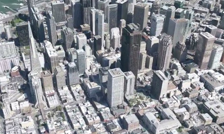
3D cityscapes
3D is the most attention-grabbing announcement today, although it's worth re-stressing that it's part of the Google Earth mobile apps, not Google Maps.
The cityscapes will be introduced initially into the Google Earth apps for Android and iOS, with the desktop version getting them at a later point. Google says that by the end of 2012, it will have 3D coverage for "metropolitan areas with a combined population of 300 million people".
3D models of buildings have been in Google Earth since its early days, said Parsons, but the company has found a way to automate the modelling process using aerial photography. "We can automatically create 3D models not just of buildings, but trees, structures like large monuments and so on," he said.
Parsons added that while most 3D in Google Earth has been in North America so far, "we are going to be rolling this out in EMEA over the next few months. The same technology is coming to Europe, and you'll be able to see some UK cities in 3D."
Why, though? 3D cities might look pretty, but what are the actual benefits to this kind of technology besides swooping virtually over San Francisco or London to show off a smartphone or tablet?
"Behind the scenes, this is very valuable for future applications like augmented reality," said Parsons.
"It gives you the ability to attach information to objects in three dimensions. For example, I'm currently sitting on the sixth floor of an office in Soho, and that's three-dimensional information. Increasingly, mapping will be more and more 3D both online, and on mobile devices."
It's notable that the latter are getting the new 3D feature first: a sign of Google's priorities when it comes to rolling out new mapping functionality across Google Maps and Google Earth.
"We think mapping and geographical information is probably most useful when you're mobile," said Parsons. "We have been mobile-first in Google Maps for quite a while," added McClendon. "The largest consumers of map data in the future will be mobile."
Offline mapping
Those priorities are also reflected in the offline Google Maps for Android announcement, which means people will be able to download the map for a specific city or area before travelling there, and save on data usage/costs when they arrive.
Parsons says it's one of the most-demanded features from Google Maps users. McClendon said that Google is capping download sizes to around 50MB – "You can get almost all of the San Francisco Bay area… The detail you'll get down to is all of the streets, all of the labels and all of the POIs [points of interest]."
Its launch may also encourage more Android users to download the standalone Google Maps app from the Google Play store, rather than wait for their operator / handset maker to push out an update to the Android OS (and thus its embedded maps app).
All of this begs the question: what about iOS? All concerned at Google are playing a straight bat, as you'd imagine.
"The maps application on iOS has always been developed by Apple, who made use of our mapping tiles in the background," said Parsons. "That's always been something that's in their control."
McClendon was equally diplomatic on iOS: "It's an excellent platform and we see it as one of the many devices that we'd like to provide Google Maps on."
Of course, Google could launch a standalone Google Maps app for iOS, just as it has on Android. But it will be interesting to see any Apple WWDC announcements on its own mapping plans include offline access to match Android.
Amid the interest in the 3D Google Earth cities and offline Android maps, the Street View Trekker news risks getting sidelined, but it's noteworthy too.
Once, the technology for capturing images for Google Street View had to be carted around in a car. Then it was shrunk down for a tricycle. Now it can be squeezed into a rucksack, enabling Googlers to explore areas on foot (think canyons, mountains, national parks…) and capture them for Street View too.
"Up Snowdon, down the Grand Canyon, out into the wilds of England, Scotland and Wales… We can take people to places they wouldn't visit," said Parsons. "It's a fantastic opportunity for remote field trips, too."
From cars to tricycles to rucksacks. How long before the Street View capture technology fits in a smartphone, and could thus be used by anyone?
Parsons said this is already happening, sort of. He cites a product launched by Google six months ago, without much fanfare, calledPhototours, which takes photos that people have taken of landmarks and stitches them together. Not quite a user-generated Street View, but a step in that direction.
Contextual cartography
Google's announcements today play into a wider picture of how digital maps are evolving: the interconnection between the actual mapping data – 3D images included – and all the other data and content floating about in the cloud with location tags.
How to make sense of that, and produce useful maps that also serve up whatever information and/or content is relevant to that particular person at that particular time?
"For cartography, it's never been what you include on the map, but what you take off that's important," said Parsons. "We're now taking that beyond traditional cartography: if you're looking through your augmented reality glasses, what information would be relevant to you at that point in time?"
A reference there to Google's Project Glass – the augmented reality spectacles that chief executive Larry Page has been spotted wearing in public several times this year.
"We're perhaps getting to the point where every map is unique for every individual for their particular task," said Parsons. "A map I would see might be different to a map you'd see."
Attention will turn now to see what Apple has up its sleeves, but Google is clearly keen to be ready for any competition. "While we may never create the perfect map, we're going to get much closer than we are today," said McClendon.


